

Crossroads and Characters
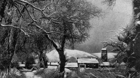
31. FROM THE HIGH ROAD TO LEADKETTY.
This 1920's north-west view of Dunning was taken from a tree-lined avenue which on old deeds was named Leadketty High Road and which led from the ford at the Lower Granco to a once flourishing hamlet called Leadketty. The house left of the steeple was called at one time Castle Grange. Was this the grange or granary of Duncrub, and hence the origin of the name Granco? The field here is said to have another historic context, the scene in A.D 965 of the battle of Duncrub for the royal succession. A standing stone in the field allegedly marks where one of the defeated, the Abbot of Dunkeld, was slain. A similar stone said to show where another of the defeated died, the Mormaor (or Steward) of Atholl, can be seen south of Dunning at a farm called The Knowes.